
A Diaspora View of Africa
Time to Correct the World Map

By Gregory Simpkins
When most of us went to school, we learned geography through the Mercator map of the world, not realizing just how inaccurate this view of the earth really was. However, there is a growing movement to change the map on which students learn and to which we all refer, as covered in a September 9 article in the Citizen Tribune.
“For centuries, this map has minimized Africa, feeding into a narrative that the continent is smaller, peripheral and less important,” said Fara Ndiaye, co-founder of Speak Up Africa, which is leading the campaign alongside another advocacy group, Africa No Filter, the article stated.
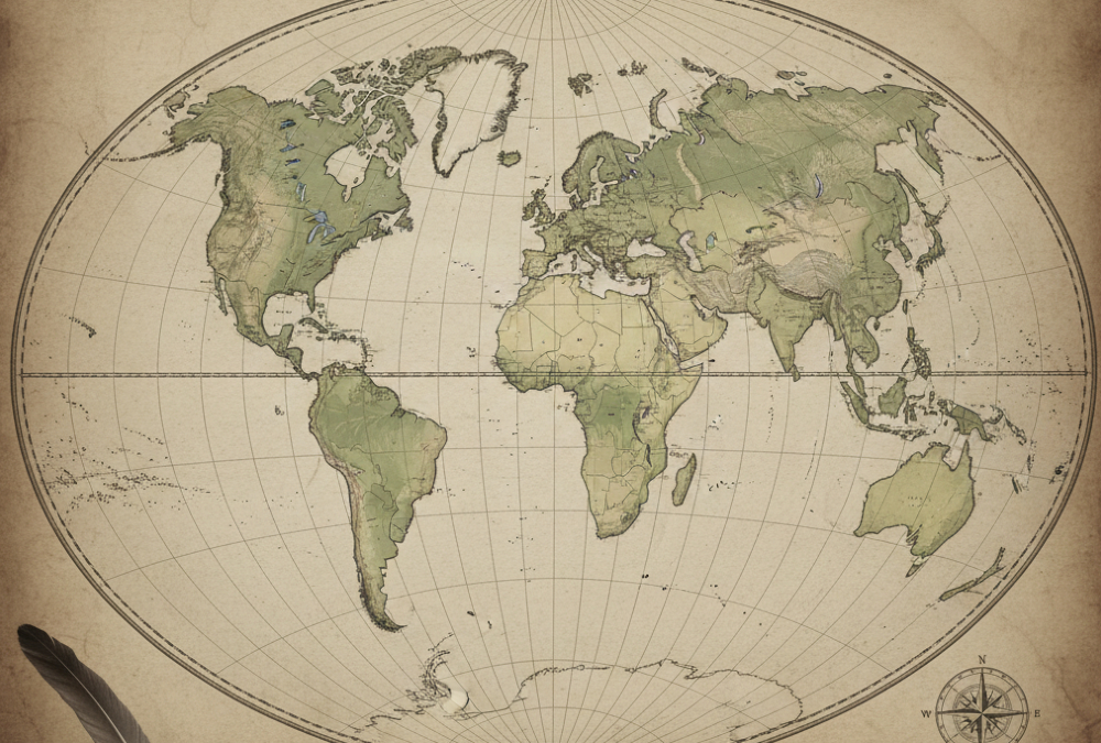
Accurately translating the Earth’s sphere into a flat map always calls for compromises, requiring parts to be stretched, cut or left out, experts told Agence France Presse.
Historically, maps have reflected the worldview of their makers.
Babylonian clay tablets from the sixth century BC placed their empire at the center of the world, while medieval European charts often focused on religious sites.
Choices must be made: a world map will look quite different depending on whether Australia, Siberia or Europe is placed at its center.
The Flawed Legacy of the Mercator Projection
Today’s most-used map was designed for maritime navigation by Flemish cartographer Gerardus Mercator in 1569, focusing on accurate depictions of the shapes and angles of land masses, but their relative sizes were often inaccurate. Mercator’s projection inflated northern regions and compressed equatorial ones, making Europe and North America appear much larger, while shrinking Africa and South America.
The distortions are stark: a 100-square-kilometre patch around Oslo, Norway, looks four times larger than the same area around Nairobi, Kenya. Greenland appears as large as Africa, even though it is 14 times smaller.
An instant classic when first published in 1991, the book How to Lie with Maps by Mark Monmonier revealed how the choices mapmakers make – consciously or unconsciously – mean that every map inevitably presents only one of many possible stories about the places it depicts.
The principles outlined back then remain true today, despite significant technological changes in the making and use of maps. The introduction and spread of digital maps and mapping software, however, have added new elements to the ever-evolving landscape of modern mapmaking.
Modern Alternatives and the Push for Accuracy
The third edition of this book has been updated for the digital age and examines the numerous ways that technology offers new opportunities for cartographic mischief, deception and propaganda. While retaining the same brevity, range and humor as its predecessors, this third edition includes significant updates throughout as well as new chapters on image maps, prohibitive cartography and online maps.
It also includes an expanded section of color images and an updated list of sources for further reading.
According to The Guardian on August 28, most modern world maps show distributions; relative densities are what matters. Equal-area projections are required, and using Mercator for such purposes is geographical illiteracy.
With digital data and computer programs, many different equal-area projections are at everyone’s fingertips: cylindrical, azimuthal, conic – and oblique or recentered versions of any.
There are also better alternatives to Mercator. The Equal Earth projection, introduced in 2018, gives a truer sense of area while retaining a visually intuitive layout.
Earlier attempts, such as the Goode homolosine or the Peters projection, made similar efforts to redress the balance. None is perfect.
Representing a sphere on a flat plane requires compromise. But the point is not perfection; it is honesty.
And honesty requires acknowledging distortion where it matters most.
Leadership depends on an accurate starting point. Whether in business or politics, vision without truth is fantasy.
Maps as Symbols of Power and Perception
It’s a long-running debate, but for many it was popularized by Aaron Sorkin’s West Wing TV drama. In a famous scene from 2001, a group of earnest cartographers explain to a White House press secretary how Mercator has misled generations into believing Greenland is the spatial equal of Africa.
The exchange plays for laughs. But it also delivers a serious truth.
Start with the wrong map, and you risk ending with the wrong conclusions. That observation has a broader resonance.
Leadership depends on an accurate starting point. Whether in business or politics, vision without truth is fantasy.
Geographers were using Mercator corrections long before the Peters Projection and Equal Earth were promoted. Shape distortion can be reduced by intersecting the Earth at two standard parallels or meridians, or by interruption – as in the widely used gores of the universal transverse Mercator projection.
Projections can be focused on any area of interest: the best for Africa could cut the Earth at two standard parallels (10 and 30 degrees east), or a 2,000 kilometer radius circle centered somewhere around the Central African Republic. But any map boundary is unreal.
Again, the Mercator projection was adopted for navigation, whether for trade, exploration or colonialism. It shows the correct shape of small areas and portrays compass directions as straight lines but does not show the shortest routes.
Cartographic distortion would be forgivable if it were confined to sailing charts. But for generations of policymakers – and of students – the world has been presented through a lens that flatters the powerful and diminishes the rest.
Another Monmonier book, Rhumb Lines and Map Wars, makes the point that empires were driven by politics and economics more than classroom atlases – a point echoed by critics who say Mercator has become overrated as a tool of western imperialism. It is true that colonialism didn’t need maps to justify itself, but maps helped to naturalize its worldview.
All geographers will want to see less use of a world map that exaggerates/emphasizes Greenland, Russia and Canada. And all statesmen should have a proper globe in their offices.
A Global Movement for Cartographic Justice
Recognizing the political importance of as correct world map, the African Union, a continental union of 55 member states, has endorsed a campaign to have organizations around the world replace the Mercator map with an alternative map that more accurately reflects the size of Africa. The effort is also being championed by the Caribbean Community, an intergovernmental group of 15 member states.
The Mercator projection was born, undoubtedly, of European priorities in an age of empire. To continue using it as the default projection is surely to perpetuate those priorities.
By contrast, adopting, say, Equal Earth is not only more geographically sound but symbolically important. It makes clear that Africa won’t continue to be diminished when, in fact, it is vast in scale and promise.
Critics may complain that changing maps is only symbolic. But symbols mold perception, and perception drives decisions.
Draw Africa small, and it is treated as small; draw it true, and its scale and potential become harder to ignore. The African Union and the Caribbean Community realize this, which is why they are both championing this effort.
It part of an overall effort by the entire Africa Diaspora to correct misrepresentations of the past. History also is being rewritten, as discoveries, inventions and leadership by African people are being brought to the forefront after being shaded for so long.
This effort is important not just for the descendants of Africa, but for the rest of the world as well. Seeing the truth of the past helps to correct our understanding of the present and our proper path to a truthful and mutually beneficial planned path to the future.
Gregory Simpkins, a longtime specialist in African policy development, is the Principal of 21st Century Solutions. He consults with organizations on African policy issues generally, especially in relating to the U.S. Government. He further acts as a consultant to the African Merchants Association, where he advises the Association in its efforts to stimulate an increase in trade between several hundred African Diaspora small and medium enterprises and their African partners.
