
News
Hurricane Beryl update: Jamaica braces for impact
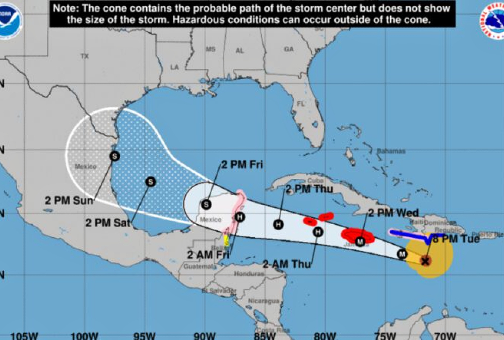
Hurricane Beryl has slightly weakened to a Category 4 hurricane with maximum sustained winds of 241 kph (150 mph) as of Tuesday night. Despite this, it remains a formidable storm and is projected to approach or possibly make landfall in Jamaica on Wednesday as a major hurricane.
In response to the looming threat, Jamaica’s Prime Minister Andrew Holness has instituted a nationwide curfew from 6 a.m. to 6 p.m. on Wednesday. Additionally, the entire island has been declared a disaster area for the next seven days under section 26 of the National Disaster Risk Management Act.
Authorities have issued an evacuation order for regions prone to landslides and flooding to ensure the safety of residents.
As of 8 p.m. Tuesday, Hurricane Beryl was located 360 miles east-southeast of Kingston, Jamaica, moving west-northwest at a speed of 35 kph (22 mph). The hurricane’s powerful winds extend up to 64 kilometers (40 miles) from its center, with tropical-storm-force winds reaching up to 298 kilometers (185 miles).
The National Hurricane Center (NHC) has projected that Beryl will swiftly traverse the central Caribbean Sea, potentially passing near or over Jamaica on Wednesday. Following this, the hurricane’s center is expected to move near or over the Cayman Islands by Wednesday night or early Thursday, before nearing the Yucatan Peninsula of Mexico on Thursday night.
The NHC has warned of “life-threatening” winds and a storm surge of 5 to 8 feet likely to impact Jamaica. The island is also expected to receive 4 to 8 inches of rain on Wednesday, with isolated areas possibly experiencing up to 12 inches. Officials have advised residents in flood-prone areas to prepare for evacuation.
In a public address, Prime Minister Holness urged Jamaicans to take the hurricane threat seriously but also emphasized that there is no need to panic.
The Cayman Islands could face a storm surge of 2 to 4 feet. While Haiti and the Dominican Republic are not directly in Beryl’s path, the hurricane could still generate a storm surge of 1 to 3 feet along their southern coasts. These areas are expected to experience tropical storm conditions by Tuesday night, with 2 to 6 inches of rain possible from Beryl’s outer bands.
Over the weekend, Beryl became the strongest June hurricane on record, with maximum sustained winds of 225 kph (140 mph). It is the first Category 4 storm to form in June and the earliest Category 4 hurricane on record in the Atlantic Basin. Remarkably, Beryl intensified from a tropical depression to a major hurricane in just 42 hours, a rapid intensification achieved by only six other Atlantic hurricanes, none of which occurred before September, according to hurricane expert Sam Lillo.
Beryl made landfall in the Grenadine Islands north of Grenada on Monday as a powerful Category 4 storm with sustained winds of 250 kph (155 mph), just shy of Category 5 status.
