
News
Dorian makes landfall in Bahamas as category 5 Hurricane
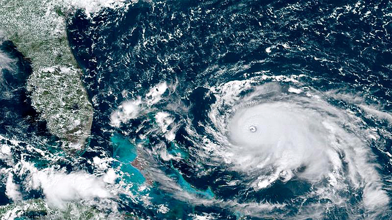
AP | Hurricane Dorian struck the northern Bahamas on Sunday as a catastrophic Category 5 storm, its nearly 300 km/h (186 mph) winds ripping off roofs and tearing down power lines as hundreds hunkered in schools, churches and other shelters.
The 2nd-strongest Atlantic hurricane since 1950, Dorian hit land in Elbow Cay in the Abaco Islands after authorities made last-minute pleas for those in low-lying areas to evacuate. But officials recognized there were not many structures on higher ground on the largely flat archipelago.
Millions from Florida to the Carolinas kept a wary eye on the slow-moving Dorian amid indications it would veer sharply northeastward after passing the Bahamas and track up the U.S. Southeast seaboard. But authorities warned that even if its core did not make U.S. landfall and stayed offshore, the potent storm would likely hammer U.S. coastal areas with powerful winds and heavy surf.
The National Hurricane Center in Miami said Dorian’s maximum sustained winds at landfall were 295 km/h (183 mph), up from 281 km/h (175 mph). It is moving west at 11 km/h (6.8 mph). “Catastrophic conditions” are occurring in The Abaco Islands and expected across Grand Bahama later in the day, the center said.
Dorian was second only to Hurricane Allen in 1980, with its 306 km/h (190 mph) winds.
“It’s going to be really, really bad for the Bahamas,” Colorado State University hurricane researcher Phil Klotzbach said.
In the northern stretches of the Bahamas archipelago, hotels closed, residents boarded up homes and officials hired boats to move people from low-lying areas to bigger islands as Dorian approached.
Bahamas Prime Minister Hubert Minnis warned that any “who do not evacuate are placing themselves in extreme danger and can expect a catastrophic consequence.”
Kwasi Thompson, minister of state for Grand Bahama island, urged residents to “please, please heed the warning. We have no more time available.”
Still, dozens of people were ignoring evacuation orders, officials said, and they were warned that they were placing their lives in danger.
Silbert Mills, owner of the Bahamas Christian Network, said trees and power lines were already down in The Abaco Islands and that some roads were impassable.
“We cannot stress the amount of devastation and catastrophic impact that Hurricane Dorian is expected to bring,” said Shavonne Moxey-Bonamy, the Bahamas chief meteorologist.
Meanwhile, Klotzbach, the hurricane researcher, warned of Dorian’s catastrophic strength: “Abaco is going to get wiped.”
Over 2 or 3 days, the slow-moving hurricane could dump as much as 1 meter (4 feet) of rain, unleash devastating winds and whip up a dangerous storm surge, said private meteorologist Ryan Maue, seconding some of the most reliable computer models.
Government spokesman Kevin Harris said Dorian was expected to affect 73,000 residents and 21,000 homes. Authorities closed airports for The Abaco Islands, Grand Bahama and Bimini, but Lynden Pindling International Airport in the capital of Nassau remained open.
The sounds of hammers and cash registers echoed across the Bahamas as the archipelago that lies just southeast of Florida rushed to prepare for Hurricane Dorian.
The Bahamas archipelago is frequently hit by hurricanes. Construction codes require homes to have metal reinforcements for roof beams to withstand winds into the upper limits of a Category 4 hurricane, and compliance is generally tight for residents who can afford it.
Risks are higher in poorer communities, which typically have wooden homes and are generally in lower-lying areas.
The slow-crawling storm was predicted to take until Monday afternoon to pass over the Bahamas, and then turn sharply and skirt up the U.S. coast, staying just off Florida and Georgia on Tuesday and Wednesday and then buffeting South Carolina and North Carolina on Thursday.
Dorian is a powerful but small hurricane with hurricane force winds Sunday only extending 47 kilometers (29 miles) to the west, but they are expecting to grow a bit. That makes forecasting the storm’s path — either just off the coast or skirting it — delicate and difficult.
