A Diaspora View of Africa
US Dismisses UN Effort to Resize Map of Africa


By Gregory Simpkins
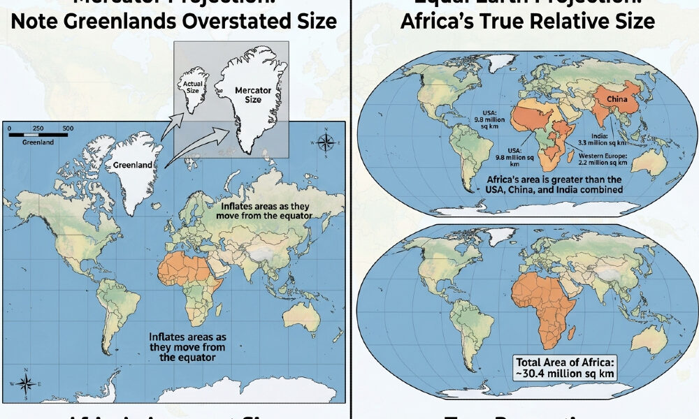
Much has been said and written about the international campaign to right size the map of Africa. A resolution sponsored by Togo and the African Union to phase out the 1569 Mercator projection was recently successfully approved in the UN General Assembly by a vote of 164-1, including former colonial powers such as the United Kingdom and France. The lone holdout was the United States. Six countries abstained.
This non-binding measure encourages governments, schools and tech companies to use “Equal Earth” or other equal-area projections when relative size matters. It explicitly states that it “in no way challenges the use of the Mercator projection for maritime and aerial navigation.”
The argument behind it is that the Mercator distorts size – making Greenland look similar to Africa, when Africa is actually about 14 times larger. The UN noted this “contributes to minimizing the perceived sizes of Africa, Latin America and south Asia, and perpetuating an unbalanced view of the world.”
The nations that voted for the resolution said they did so as a symbolic correction and educational tool. It was emphasized that maps influence how we understand development, investment and geography.
Speaking on behalf of his government and co-sponsor the African Union, Togolese Foreign Minister Robert Dussey said:
“A fair world begins with a fair map. Maps shape our understanding of the world. They guide education, nourish the imagination and influence collective perceptions. The Mercator projection has for too long minimized the perceived size of Africa, Latin America and South Asia.”
“Africa’s misrepresentation on world maps is not just a cartographic error – it’s a narrative issue,” Lerato Mogoatlhe from Africa No Filter, one of the groups behind the campaign to ditch the Mercator map, told the BBC.
It was part of efforts to stop the “world’s longest misinformation and disinformation” about Africa, she added.
For Kenyan geographer Kioko Muendo, the Mercator map has implicitly downplayed the African continent’s vast resources, population and investment opportunities.
Beyond Symbolism: The Business Case
The resizing of the Africa map is far more than symbolic, as international business consultant John Kourkoutas explained in a recent blog post on LinkedIn:
“A manufacturer decides to ‘cover Africa’ and appoints one distributor to do it. Usually in Johannesburg or Nairobi, because those are the two names they know. Then they cannot understand why nothing moves in West Africa,” Kourkoutas explained.
“Lagos to Nairobi is about 3,800 kilometers (2,361 miles). That is roughly London to Tehran. Nobody would appoint a single distributor in London and instruct them to also cover Iran. But on the map in most people’s heads, Africa is a manageable block about the size of Europe with a couple of big cities in it. So the plan looks reasonable, the budget gets set against it, and the whole thing quietly underperforms for two years.”
In addition to the logistical difficulties for businesses because of the distorted map, investors, NGOs and companies looking at a Mercator map have seen Africa as a collection of “small” countries. That has underplayed market size, infrastructure needs and logistical scale. At 30.3 million km². the US, China, India, Europe and Japan would all fit inside the continent with room left over.
Humanitarian Stakes and Historical Roots
Scale also has important implications for humanitarian affairs. A conflict in the Democratic Republic of Congo looks smaller than a snowstorm in Canada on Mercator. Perceived size affects resource allocation and planning. If a continent looks small, its population of 1.4 billion people and 54 countries can look more “manageable” than it is.
The UN and AU argue that 500 years of seeing Europe and North America enlarged reinforced a subconscious idea of “centrality” and “importance.” Africa, Latin America and South Asia have all appeared minimized.
Explaining the “No” Vote
In explaining why the United States cast the lone “no” vote on the resolution, Yaryna Ferencevych, Deputy Representative of the United States to the Economic and Social Council, explained that the US voted “no” not because it disputed Africa’s real size, but because it framed the resolution as symbolic politics rather than practical policy.
“While presented as anodyne effort to update cartographic proportions, we view this initiative as part of a much larger and more radical ideological project. The United Nations was created to maintain international peace and security, promote prosperity, and foster good relations among nations. Debating 16th-century map projections and their role in promoting reparations and cognitive justice does not advance those goals,” she stated.
“This resolution is a distraction from the genuine problems facing this body. Resolutions like this one and the ideological agenda they promote are barnacles on our work here and the reason this institution is losing its credibility. The United States notes that the Mercator projection remains fully suited for maritime and aerial navigation. We encourage educational accuracy, but we do not believe this requires a General Assembly resolution.”
The Trump administration is very sensitive about issues such as reparations, which has been raised again at the UN in recent months. However, this issue is not related to that nor is it merely symbolic. As Kourkoutas explained, changing the Africa map has real world financial implications that have been ignored.
A Shifting Balance of Power: The Rise of the G3
The United States has found it difficult to get cooperation on issues with which it is concerned from the UN and other international bodies in which it is a member. Given the difficulties the United States has had lacking firm partnerships with China and Russia, perhaps the Trump team is advising the president that the G7, the UN and other international coalitions have lessened value because they don’t directly and effectively address what are seen as the most pressing issues, such as Iran and the Strait of Hormuz. Perhaps China and Russia see the trilateral relationship as superseding the BRICS coalition as well.
In a LinkedIn article by Edwin Kornelius for Geopolitics, he wrote that President Trump increasingly treats the US, China and Russia as the decisive great powers in global affairs. A particularly revealing development is the possibility of a Trump-Xi-Putin trilateral meeting at November 2026 APEC – Asia-Pacific Economic Cooperation summit. The Kremlin says the idea has been discussed with the White House. The meeting is scheduled for November 18-19 at Shenzhen in Guangdong province. The theme is “Building an Asia-Pacific Community to Prosper Together.” G3 is very different from the traditional G7 model, where the emphasis is on coordination among the US and its major democratic allies. Of course, the three governments have interests beyond the Pacific region.
So if the perceived superpowers decide to work out the world’s problems on their own, what are the implications for the rest of the world?
Gregory Simpkins, a longtime specialist in African policy development, is the Principal of 21st Century Solutions. He consults with organizations on African policy issues generally, especially in relating to the U.S. Government. He further acts as a consultant to the African Merchants Association, where he advises the Association in its efforts to stimulate an increase in trade between several hundred African Diaspora small and medium enterprises and their African partners.