News
Sandy now a category 1 hurricane as it hits Jamaica
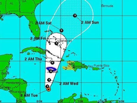
Projected path of Hurricane Sandy. IMAGE/U.S. National Hurricane Center
Hurricane Sandy pounded Jamaica with heavy rain as it headed for landfall Wednesday near the country’s most populous city on a track that would carry it across the Caribbean island to Cuba, and a possible threat to Florida.
The country’s international airports closed, cruise ships changed their itineraries and police ordered 48-hour curfews in major towns to keep people off the streets and deter looting as the late-season storm neared Jamaica’s south coast. Police slowly drove through drenched communities in the capital of Kingston with their cruisers’ lights flashing.
The 18th named storm of the Atlantic hurricane season was forecast to make landfall in the vicinity of Kingston Wednesday afternoon and then spin on into eastern Cuba overnight.
Forecasters at the U.S. National Hurricane Center in Miami said tropical storm conditions were possible along the southeast Florida coast, the Upper Keys and Florida Bay by Friday morning. A tropical storm watch also may be required for parts of east-central Florida later Wednesday morning, the centre said.
Across Jamaica, people were jittery about Sandy’s approach.
While Jamaica was ravaged by bands from Hurricane Ivan in 2004 and other powerful hurricanes centered offshore, the eye of a hurricane has not carved across the island since Hurricane Gilbert in 1988, according to Jamaican meteorologist Jacqueline Spence.
As a light rain fell from slate grey skies on Wednesday morning, Kingston resident Andre Howt tried to finish repairs to a neighbor’s roof that leaks badly even during a common rain storm. Steady drips from the concrete ceiling were filling plastic buckets.
“We don’t have much time. We heard on the radio that the hurricane was coming this way,” he said in the poor Kingston community of Standpipe, situated next to one of the debris-clogged gullies that crisscross the capital. “We’ll be getting wet.”
Dangerous flash floods and mudslides were a threat for the tropical island of roughly 2.7 million inhabitants, especially in mountainous areas, Jamaica’s meteorological service said.
The island’s bus service said it was on standby to evacuate residents of Kintyre, which is typically pummeled even by relatively minor storms. Emergency officials ordered mandatory evacuations for people living in historically hard-hit low-lying and coastal towns.
The storm was predicted to drop as much as 25 centimetres (12 inches) of rain, especially over central and eastern parts of Jamaica, the country’s meteorological service said. Some isolated spots could see as much as 50 centimetres (20 inches), according to U.S. forecasters. Battering waves and a strong storm surge were also forecast. By Wednesday morning, sea water was already washing over the streets of Port Royal, a depressed fishing village at the tip of a spit of land near Kingston’s airport.
More than 100 fishermen were stranded in outlying Pedro Cays, a lobster- and conch-rich area about 66 kilometres (40 miles) off Jamaica’s southern coast. Some of them told local media they lacked fuel to get back to the mainland, but authorities said they wilfully disobeyed an evacuation order.
Airports in Kingston and Montego Bay shut down for the day and Royal Caribbean Cruises Ltd. announced that its Allure of the Seas megaship would not stop at Jamaica’s northern Falmouth terminal on Wednesday, remaining at sea instead.
To deter looters and other criminals, Deputy Police Commissioner Glenmore Hinds warned that police “will react swiftly to protect life and property.”
Meanwhile, Prime Minister Portia Simpson-Miller cut short an official visit to Canada to return to the island for the hurricane’s passage.
Late Wednesday morning, Sandy was a Category 1 hurricane with maximum sustained winds of 130 kph (80 mph) and was centered 100 kilometres (65 miles) south of Kingston. It was moving north-northeast at 20 kph (13 mph).
Meanwhile, U.S. forecasters said Tropical Storm Tony had formed over the open Atlantic, but posed no threat to land. The storm had maximum sustained winds of about 85 kph (50 mph) and it was moving east-northeast at 33 kph (21 mph ). Its center was 2,005 kilometres (1,245 miles) west-southwest of the Azores.
Copyright 2012 The Associated Press