News
Antigua & Barbuda hardest hit as Hurricane Irma Slams Into the Caribbean
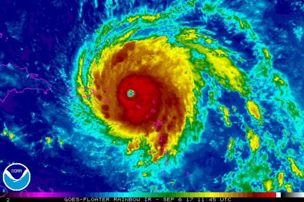
(AP) – Hurricane Irma roared into the Caribbean with record force early Wednesday, its 295 km/h (185 mph) winds shaking homes and flooding buildings on a chain of small islands along a path toward Puerto Rico, Cuba and Hispaniola and a possible direct hit on densely populated South Florida.
The strongest Atlantic Ocean hurricane ever recorded passed almost directly over the island of Barbuda, causing widespread flooding and downing trees.
The regional authority for Guadeloupe and neighboring islands said the fire station in Saint Barthelemy was flooded by more than 1 meter (3 feet) of water and no rescue vehicles could move. The government headquarters on Saint Martin was partially destroyed.
Antigua & Barbuda Prime Minister Gaston Browne said the twin-island nation appears to have weathered its brush with Hurricane Irma with no deaths, though he noted that the government had only done a preliminary assessment of Barbuda. There were widespread reports of property damage but he says the public and government had prepared well for the storm.
“We in Antigua have weathered the most powerful hurricane ever to storm its way through the Caribbean,” the prime minister said. “And we have done so with stunning results.”
Hurricane Irma had maximum winds of 295 km/h (185 mph) as of 11 a.m. Wednesday and was producing dangerous storm surge and heavy rain. The center of the storm was about 110 kilometers (65 miles) east-southeast of St. Thomas in the U.S. Virgin Islands and about 225 kilometers (140 miles) east of San Juan, Puerto Rico. It was heading west-north-west at 26 km/h (16 mph).
As the eye of Hurricane Irma passed over Barbuda around 2 a.m., phone lines went down under heavy rain and howling winds that sent debris flying as people huddled in their homes or government shelters.
The storm ripped the roof off the island’s police headquarters, forcing officers to seek refuge in the fire station and at the community center that served as an official shelter. The Category 5 storm also knocked out communication between both islands.
The U.S. National Hurricane Center said Irma’s winds would fluctuate but the storm would likely remain at Category 4 or 5 strength for the next day or two. The most dangerous winds, usually nearest to the eye, were forecast to pass near the northern Virgin Islands and near or just north of Puerto Rico on Wednesday.
Four other storms have had winds as strong in the overall Atlantic region, but they were in the Caribbean Sea or the Gulf of Mexico, which usually have warmer waters. Hurricane Allen hit 303 km/h(190 mph) in 1980, while 2005’s Wilma, 1988’s Gilbert and a 1935 great Florida Keys storm all had 295 km/h (185 mph) winds.
The northern Leeward Islands were expected to see normal tide levels rise by as much as 3.3 meters (11 feet), while the Turks & Caicos Islands and south eastern Bahamas could see surge of 6 meters (20 feet) and higher waves later in the week, forecasters said.
Bahamas Prime Minister Hubert Minnis said his government was evacuating 6 islands in the south because authorities would not be able to help anyone caught in the “potentially catastrophic” wind, flooding and storm surge. People there would be flown to Nassau in what he called the largest storm evacuation in the country’s history.
“The price you may pay for not evacuating is your life or serious physical harm,” Minnis said.
The eye of the storm was expected to rip westward on a path taking it a little north of Puerto Rico, the Dominican Republic, Haiti and Cuba.
The northern parts of the Dominican Republic and Haiti could see 25 centimeters (10 inches) of rain, with as much as 50 centimeters (20 inches) in the south east Bahamas and Turks and Caicos.
The storm seemed almost certain to hit the United States by early next week.